Cartographic controversy puts Spain at odds with Google
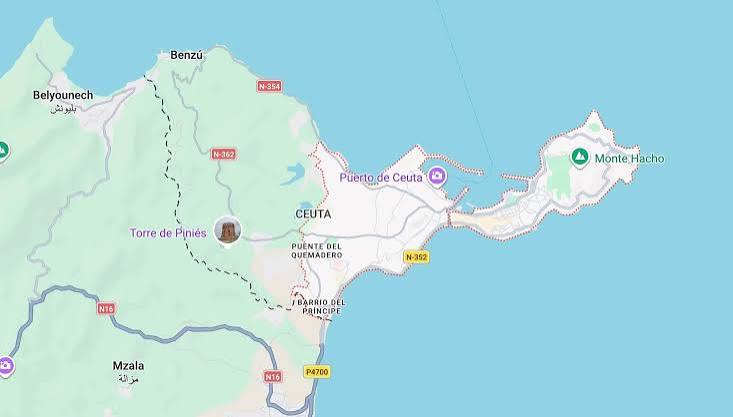
The file of the occupied cities of Ceuta and Melilla is once again dominating the media landscape in Spain, this time through digital platforms. The use of dashed lines by Google Maps to delineate the land borders of both cities has caused widespread dissatisfaction among Spanish authorities.
This cartographic symbol, used globally to denote territories with unresolved or disputed sovereignty, has been viewed by Spanish parties as a threat to their unilateral narrative regarding the legal status of the cities, prompting them to exert pressure on the American company.
Spanish moves to pressure Google
In this context, the Spanish association “Zelundia” has led a campaign directed at Google’s management, demanding precise technical clarifications as to why this type of border delineation was chosen. In its correspondence, the association questions whether this technical change means that Google has begun classifying the two cities as an “claimed” area or a sovereignty dispute, fearing that it will embed the idea among millions of users around the world that Spanish sovereignty over them is not settled.
Extreme sensitivity towards digital maps
This incident comes in a political and media climate that is extremely sensitive in Madrid regarding the digital representation of borders. The Spanish government previously faced similar embarrassment, which led to the removal of an official map from the “Casa 47” real estate portal, following harsh criticism of how the areas and borders were displayed, demonstrating the extent of Spanish concern over any cartographic hint that touches on the status of the two cities.
Sovereignty file asserts itself digitally
This digital debate reaffirms the fact that the dossier of Ceuta, Melilla, and the Chafarinas Islands remains a central sovereignty issue for the Kingdom of Morocco, which continuously demands the restitution of its occupied territories. Despite Spanish attempts to move past the conflictual nature of the file, global platforms like Google Maps continue to impose a new reality that reflects the complexity of this historical dossier and its current status as a sovereignty issue on the international table.





💬 Share your opinion
We welcome constructive opinions and ask you to maintain politeness.
0 comments